Location Services
Location data to power your applications.
Azure Maps powers a range of customer-facing and backend applications, providing geolocation and geocoding services in single or batch requests.
80% of business data has a location component.
Our comprehensive suite of features lets you integrate dynamic and precise location-based functionalities seamlessly into your solutions. From geocoding to routing, mapping to spatial analysis, Azure Maps API equips you with the tools you need to enhance user experiences and drive business efficiency.

Precision and scalability
Leverage high-quality location services to ensure accurate geocoding, routing, and mapping for your applications and seamlessly scale your applications to accommodate growing user bases and data volumes without sacrificing performance.

Limitless flexibility
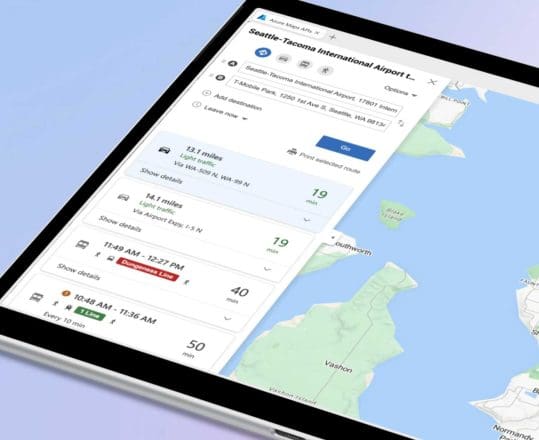
Optimize routes and streamline workflows with traffic data, reducing travel times and enhancing productivity with customized maps and functionalities to suit your specific business needs and user preferences.

Insights that give you the edge
Gain valuable insights from spatial data analysis to make informed decisions and drive strategic initiatives, helping you stay ahead of the curve with access to cutting-edge features and continuous updates that enhance your applications.
Location Services
Azure Maps enriches your business data to generate new insights for your business.
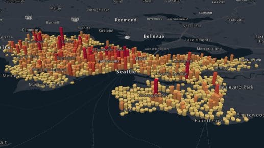
Visualize buildings, terrain, and natural features in stunning detail, offering users a compelling perspective on their environment.
Search
Using geolocation services, developers can search for addresses, places, and business listings by name, category, and other geographic information. The accurate coordinates provided by our services can also be used as parameter values with Route, Weather, and other Azure Maps REST APIs.

Geocoding
Azure Maps’ geocoding services allow you to look up and convert addresses to coordinates and vice versa. It can also search for the geographic outline of an area, such as a city or country region. These location services can be used for various geolocation technologies and combined with other Azure mapping services.

Geolocation
Azure Maps API lets you resolve the IP addresses from a range of mobile and fixed internet traffic sources to determine the ISO country code of that IP traffic. This enables the easy localization of services and content for your applications.
Frequently asked questions
-
Developers get instant access to a massive amount of resources right after signing up for Azure Maps. Our documentation and interactive code samples include everything you need to know about building with our APIs.
-
Azure Maps doesn’t impose any maximum daily limits on geocoding and geolocation requests. There can be limits on the overall queries per second, depending on your plan.
-
Yes. You can start building for free with the Azure Portal right after signing up, and you’ll also get $200 in free Azure credit to help you get started. You can also experiment with our interactive code samples to see our geolocation API in action.
-
Azure Maps supports 45+ languages depending on your region. Please consult our localization page to learn more about support in your region.
More features from Azure Maps

Data and Insights
Extract priceless insights from your data with Azure Maps. Process, analyze, and achieve more with a platform that scales with you. Leverage accurate geospatial data to build better applications.
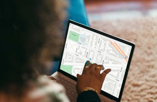
Mapping and Visualization
Get more out of your data with Azure Maps’ powerful mapping and visualization features. Use a large variety of map styles and location services to empower decision-making in your organization.

Routes and Directions
Create safer, faster, and more efficient routes by accounting for road restrictions, weather, traffic, and much more. From pedestrians to trucks, everyone moves faster with Azure Maps.
Getting Started Guide
Sign up / sign in to the Azure Portal and start building today.
Technical Documentation
Explore quickstarts, how-to-guides, tutorials, and API reference documentation.
Coding Samples
Visit the Azure Maps web control sample gallery to browse code samples.
Contact Us