Mapping and Visualization
Accurate, up-to-date interactive map data visualization for your applications.
Azure Maps empowers you to bring your mapping and visualization goals to life with unmatched precision. It provides robust tools to visualize your data on a range of customizable map styles, making it simple to connect data from various sources and power smarter decision-making. Whether it’s for location-based services or spatial analytics, Azure Maps gives you the tools to see your data in action.
Infinitely customizable
Accurate base maps and imagery. The Azure Maps API offers base maps in numerous, flexible formats to seamlessly align with your application’s needs. From streets and topography to satellite imagery, every map style is highly customizable, helping you deliver unique geospatial data mapping and visualization experiences. By integrating tools like REST APIs and Azure SDKs, you can merge your data with Azure’s dynamic resources and gain real-time insights. Discover the breadth of possibilities with Azure Maps and transform your application into a rich, visually compelling geospatial tool.

Interactive maps
Azure Maps provides dynamic, interactive maps that are tailor-made for web and mobile platforms. These maps aren’t just about viewing – they let your users interact directly with the data for deeper insights. Whether you’re tracking deliveries, visualizing complex geospatial patterns, or creating location-based services, interactive maps help users engage with content intuitively. By utilizing the flexible design tools available for mapping and visualization, you can refine everything from custom map styles to overlays and layers, ensuring that every map you deliver meets your application’s unique requirements.

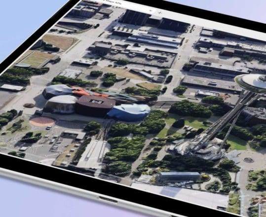
Satellite imagery
Azure Maps delivers high-resolution satellite imagery that transforms how businesses view and analyze the world. From urban planning to natural resource monitoring, satellite imagery offers a real-world perspective at scale. Whether you’re determining ideal locations for renewable energy projects or monitoring agricultural growth, this vivid imagery provides essential context. The combination of mapping APIs and satellite data ensures seamless data integration, enabling precise analysis for even the most complex geospatial applications that rely on interactive map data visualization.

Customizable UI controls
Azure Maps equips developers with a wide range of SDKs and mapping and visualization APIs to fine-tune user interfaces according to project needs. From adjusting map themes to creating intuitive widgets for easier navigation, you can design a highly personalized mapping experience. Customizable controls streamline user interactions, making it possible to add search bars, zoom tools, or even advanced real-time mapping layers. This level of customization helps businesses meet both user expectations and specific use cases without compromise.
Seamless visualization
Azure Maps specializes in seamlessly integrating visualization features that bring clarity and depth to your applications. By leveraging advanced mapping and visualization tools, you can turn complex datasets into understandable, actionable insights. Build efficient delivery networks, optimize logistics, or create engaging applications for end-users with location-based services. Mapping APIs combined with spatial analytics and real-time mapping capabilities enable cutting-edge data visualization for businesses across industries.
Maps Imagery
Azure Maps provides vector-based map tiles to support mapping and visualization for various industries, whether it’s logistics, retail, or urban development. These tiles create an interactive base for your geospatial data, enabling features like route optimization, traffic management, and high-level data overlays. Users can select from built-in options, such as road views or terrain styles, to better interpret the data on-screen. Advanced data layers allow for deeper insights when paired with interactive maps.
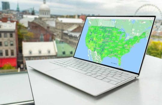
Maps Visualization
The Azure Maps API empowers users to integrate public or private datasets, transforming raw data into actionable visuals for interactive map data visualization. It supports extensive data integration, enabling businesses to visualize large-scale geospatial applications with ease. Pair this with Azure’s mapping and visualization tools to create highly localized insights, such as pinpointing the best locations for services or spotting trends within dense data structures.

Building Interactive Maps
The Azure Maps REST API and SDKs provide developers with a smooth way to incorporate interactive mapping features into their applications. From building dashboards to embedding interactive map layers, you can transform your data into a user-friendly experience. Use case examples include fleet management systems, retail heatmaps, and emergency response simulations. The mapping and visualization tools let you modify map customization levels while maintaining a clean and responsive interface.

Satellite Imagery
Satellite imagery from Azure Maps supports diverse use cases, from evaluating environmental impact to assisting disaster recovery operations. The detailed, high-resolution images allow for realistic mapping and visualization that’s especially useful for industries dealing with large-scale physical environments. With seamless API integration, satellite imagery lets you add depth and accuracy to your geospatial applications without slowing down your workflows.

Frequently asked questions
-
Absolutely not. Azure Maps is easy for developers to pick up and use regardless of their prior experience. You can use our extensive documentation base and consult our code samples for support.
-
Azure Maps doesn’t limit daily requests. There can be a limit on the overall queries per second.
-
Yes. Integrating our mapping tools with other Azure services is incredibly easy. You can integrate Azure Maps into your existing Azure subscription or Enterprise agreement.
-
Azure Maps offers localization support for a wide range of languages and regions. Visit our localization support page to learn more.
-
Yes. You can sign up for Azure Maps for free, and you’ll also get $200 in free Azure credit when you sign up.
-
Azure Maps can scale with your needs. If you exceed current service limits for your interactive map data visualization needs, you can adjust account settings or consult Azure’s support team to identify the best solution for scaling up.
-
Yes, Azure Maps supports fully customizable map styles. You can design and implement specific themes, adjust color schemes, and add layers to align maps with your brand or project goals.
-
Azure Maps provides globally reliable, up-to-date data for mapping and visualization from trusted sources. Its real-time mapping tools ensure accuracy, making it dependable for operations like logistics, navigation, and disaster response.
More features from Azure Maps

Data and Insights
Process and analyze massive amounts of location data with Azure Data services. Build bespoke solutions to complex organizational challenges with interactive map data visualization.

Location Services
Find the joy in every journey. Locate points of interest and addresses around the globe with unparalleled accuracy with powerful geocoding and reverse geocoding.

Routes and Directions
Create efficient routes for pedestrians, cars, and trucks with Azure Maps. Detect and convey road closures and traffic restrictions using mapping and visualization tools.
Getting Started Guide
Sign up / sign in to the Azure Portal and start building today.
Technical Documentation
Explore quickstarts, how-to-guides, tutorials, and API reference documentation.
Coding Samples
Visit the Azure Maps web control sample gallery to browse code samples.