
Maps Imagery
Dynamic, high-resolution vector-based maps imagery
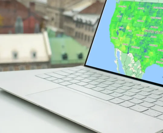
Azure Maps brings you high-resolution and up-to-date vector-based maps imagery for precise and clear visualization. Build applications with detailed geographical context that inform better decision-making.
Everything, enhanced
Azure Maps vector-based mapsImagery transforms how you visualize the world, empowering you to create innovative solutions that enrich your users’ experiences.
Unmatched Precision
Convey complex information with sharper details and a cleaner visual experience that brings clarity and insight to every project
Customizable Maps
Azure Maps vector-based maps imagery gives you the flexibility to customize map styles and add overlays and data layers for a personalized experience.
Optimized Performance
Enjoy swift, responsive maps that ensure your applications run smoothly, even when handling complex datasets or high traffic.
Interactive and Responsive
Engage your users with maps that allow users to seamlessly zoom, pan, and explore, responding intuitively to user inputs on any device.
Vector-based data representation
Azure Maps imagery’s vector tiles store geographical information in a way that’s not only more efficient but also scalable. This means sharper details and a cleaner visual experience.
Responsive zoom levels
Azure Maps satellite imagery dynamically adjusts the level of detail as you zoom in and out for optimal performance and readability. From panoramic views to street layouts, every zoom level offers clarity without compromise.
Real-time updates
Stay ahead with the latest imagery that ensures you have the most current view of your area of interest, reflecting everything from new roads and infrastructure to environmental changes.
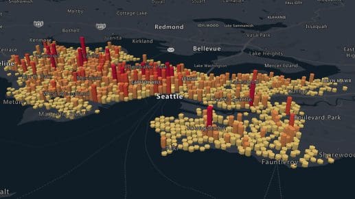
Data overlay and analyses
Azure Maps imagery lets you layer your unique datasets over high-quality maps so that you can identify patterns and explore scenarios in ways that traditional data representations cannot match.
Global coverage
Worldwide, high-quality coverage that supports a wide range of applications, including international logistics, global environmental monitoring, and cross-border services. Businesses and users have the geographical data they need, whenever and wherever.
Platform compatibility
Azure Maps’ vector-based approach ensures your maps look stunning across all devices and platforms with consistent, high-quality visuals that enhance user experience and engagement on web, desktop, or mobile applications.
Azure Maps Imagery Service
Azure Maps imagery brings your data and operations into sharp focus. With detailed maps at your fingertips, businesses and developers can make smarter decisions, optimize operations, and create unforgettable user experiences.
Azure Mapping and Visualization APIs
Advanced mapping capabilities

Vehicle routing and delivery planning
Streamline your logistics and enhance efficiency with Azure Maps. Plan the most efficient routes, significantly reduce delivery times, and improve service quality for greater customer satisfaction.

Urban planning and infrastructure development
Leverage Azure Maps satellite imagery for detailed planning, efficient resource allocation, and sustainable growth that enhances the livability and resilience of urban environments.

Innovate and transform
Build innovative map-based solutions that are as precise as they are impactful with Azure Maps imagery today.
Ready to start building?

Get started
Our platform provides you with everything you need — from subscription keys for API authentication to a plethora of code samples, demos and SDKs.

Documentation
Complete with code samples, SDK support, and detailed explanations, this is a one-stop resource for enhancing your projects with the wide range of Azure Maps APIs.

Samples
These pre-written snippets show how to perform various API calls for current weather, forecasts, and severe weather alerts, among other functionalities.
Frequently asked questions
-
Azure Maps provides a variety of high-resolution map imagery, including satellite views, aerial photographs, and street maps. These diverse imagery types can support a wide range of applications such as navigation, logistics, and environmental monitoring.
-
Yes, Azure Maps integrates seamlessly with a wide array of other Azure services such as Azure Logic Apps and Azure IoT. These applications harness the power of cloud computing to help you build comprehensive, data-driven applications. For example, Azure Maps imagery can be integrated with Azure IoT to provide real-time tracking of fleet vehicles.
-
Yes, Azure Maps offers extensive customization options that allow you to alter map styles and add overlays. It also allows for easy data integration so you can create unique visual presentations that align with your brand.
-
You can find comprehensive Azure Maps documentation for users, including SDKs, and tutorials. These resources will assist you in integrating Azure Maps satellite imagery into your applications effectively.
-
Azure Maps offers high-resolution, up-to-date imagery that enables you to plot the most efficient routes for your fleet, taking into account current road conditions, traffic updates, and environmental factors.

Azure Maps
Advanced mapping and visualization features for your applications.
More features from Azure Maps

Data and Insights
Process and analyze massive amounts of real-time and historical location data with Azure Data services to find the best possible solutions to logistics challenges.

Location Services
Map supply chains, locate POIs, and create customized experiences with powerful geolocation data, all backed by robust search APIs and extensive GIS databases.
Mapping and Visualization
Create varied, fully customizable, and interactive graphs that inform creative decision-making. Experience a new way of visualizing your data.